Trails We Took in February
From the Middle Fork Greenway to Tanawha Trail, find plenty of paths to explore in winter! Enjoy some winter views on these February trails

From the Middle Fork Greenway to Tanawha Trail, find plenty of paths to explore in winter! Enjoy some winter views on these February trails
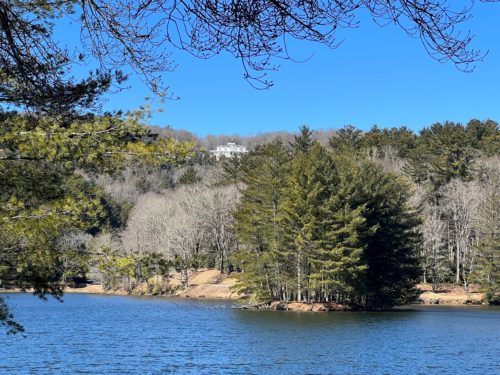
Hiking is one of the best ways to see the beauty of the Blue Ridge Mountains. There are countless trails in the area, especially along the Blue Ridge Parkway. From the myriad destination hikes and the 26 mile network at Moses Cone Park, to local sections of the Appalachian Trail and the Mountains to Sea Trail, deciding where to start can be overwhelming. Here’s a short list of some of the most popular hikes closest to Blowing Rock, and they are well-loved for good reason. You’ll find easy parking access, well-defined trails, and sights unique to this region of the Blue Ridge. Take your pick and get out there! Bass Lake LoopEasy | 1 mile loop | Access on Hwy 221, one mile from Main Street in Blowing Rock.This picturesque loop is a regular stop for many locals, and you’ll see plenty of people out walking dogs or taking a jog on most days. The trail is flat, well-maintained gravel, following a path around Bass Lake. The lake was built by Moses Cone as part of his estate, and you can see the Flat Top manor house from various points on the route. The trail is a nice location to see plenty of waterfowl and beavers and is a good fishing spot, too. The loop connects to the other 26 miles of carriage trails in Cone Park, and can be a place to take laps or a great starting point for a longer hike. Glen Burney TrailModerate to Strenuous | 3 miles total, out-and-back | Trail head inside Annie Cannon Gardens on Laurel Lane in Blowing RockThis varied trail follows the path of New Years Creek from Annie Cannon Gardens. It starts out easy, with a wide path that crosses the creek and passes behind properties in the Mayview community. After crossing the water again, the trail descends sharply into John’s River Gorge. Along the way, views of cascades and Glen Burney Falls are a beautiful highlight. Glen Mary Falls awaits at the bottom of the trail. Because of drop offs by the falls, this trail approaches steep and treacherous areas- take care to obey posted signs and stay on the trail. The trail is one way, so once you reach the bottom, the strenuous hike back to the gardens begins. The elevation change is worth it, however, as waterfalls and various stages of wild blooms and foliage are your companions along the way. Boone Fork TrailEasy to Moderate | 5 mile loop | Access at at Price Park Picnic Area at MP 296Following the Boone Fork River and tributaries, this loop provides a varied look at local flora and terrain. Through hardwood forests and rhododendron thickets, the trail also passes by small waterfalls and cascades. The trail intersects and shares some route with both the Tanawha Trail and the Mountains to Sea Trail, so take care to note signage at intersections. Rough Ridge Overlook TrailModerate to Strenuous | 0.8 miles to view | Access at Rough Ridge Overlook parking area at MP 302.8 on Blue Ridge ParkwayThis trail is especially popular because it’s easy to find and provides one of the best views in the area. From the parking area, take the trail up to the fork and turn left to go across the little wooden bridge. This is the shortest route to the top. It’s quite a climb, and you’ll know you’ve arrived when you reach the boardwalks. These have been built to protect the fragile lichen and shrub communities on the ridge- please stay on the boardwalks and trails to help ensure their survival. The trail along the ridge is actually the Tanawha Trail, so there is plenty more to see if you want to keep following the path once you reach the top. Keep in mind that Tanawha is not a loop, and that you’ll need to double back to return to your vehicle. The vista on the ridge is expansive, with views that include Grandfather, Grandmother, Hawksbill, and Pilot Mountains, along with various communities far in the distance. On very clear mornings, you can see the Charlotte skyline. Flat Top TrailModerate | 5.6 miles round trip | Access at Cone Manor at MP 294 on the Blue Ridge ParkwayAnother carriage trail in Cone Park, this route takes you to the top of Flat Top, where a fire tower waits to provide a 360 degree view above the canopy. The distance is long, but the trail is wide and inclines are not very steep so most consider it a moderate trail. About halfway up, the trail crosses a beautiful highland meadow where the graves of the Cone family are found in a small cemetery. From the top of the firetower, the communities of Blowing Rock, Boone, and others can be easily seen. The trail is out-and-back, so your return trip follows the same path. Happy Hiking!

Friends of the NC Mountains-to-Sea Trail (MST) invites hikers of all skill levels to help celebrate the trail’s birthday each year in September. Join one of the group hikes in several trail towns across the state! From Cherokee to Nags Head, you’ll find hikes from one to 12 miles, through all types of landscape, from easy to strenuous. “This will be a great opportunity to explore North Carolina’s natural beauty with the help of hike leaders who have extensive local knowledge of the trail and area attractions,” said Betsy Brown, Outreach Manager for the Friends of the MST. The 46-Mile Challenge is also a fun option for enjoying the MST in September. Hike the miles anywhere on the MST during September for a chance to win great prizes- more details coming soon. Registration for organized hikes will open later this year, and will be accessible through the Friends of the Mountains-to-Sea Trail website. Depending on the hike, there is a limit to the number of people who can register, anywhere from fifteen to a hundred. Hikes are free, though Friends encourages donations to support their continuing work on the MST. Hikers are also encouraged to hike anywhere, anytime over the weekend on their own, and share their stories. Find detailed information about this and the Hike on Your Own option at mountainstoseatrail.org/birthdayhike/ The MST Birthday Hike is not only an opportunity for hikers to learn about the MST – it is also a time for them to get to know trail communities across the state. Hikers can stick to their closest trail town, or they can travel to another area of North Carolina they wish to explore. Many towns will provide information about local events, restaurants, and attractions in the trail towns and hikers can become better acquainted with the areas. Chuck Millsaps, president of the Great Outdoor Provision Co. (GOPC), says, “We are thrilled to see so many communities hosting hikes across the state as we celebrate the Mountains-to-Sea Trail. It’s such fun to send folks out on the trail and then hear their hike stories the next time they stop by.” GOPC is the exclusive sponsor of the MST Birthday Hike. It’s a North Carolina-based outdoor equipment and clothing retailer, with nine stores across the area. This will be the seventh year of celebrating the birth of the MST, founded forty-six years ago. In 2017, the first celebration year, hikers across the state walked different legs of the 1175-mile trail, successfully hiking the entire trail in a day. The second year, solo hikers and groups were encouraged to hike any area of the trail they wished and report their journey back to Friends of MST. That tradition continues! Friends of the Mountains-to-Sea Trail is a non-profit organization whose mission is to bring together communities and volunteers to build, protect and promote the Mountains-to-Sea Trail, connecting North Carolina’s natural treasures and communities. The trail itself is 1175 miles, and spans from the Great Smoky Mountains to the Outer Banks. Updated January 2023