Waterfalls Near Blowing Rock
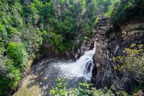
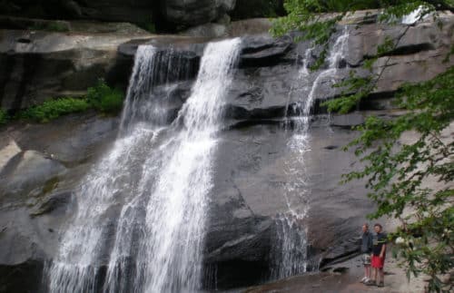
March 2025 Helene Update: Please note that many regional waterfall trails are among those that are still closed for repairs or assessments. We recommend the Spring 2025 Waterfall Trail from High Country Host- click here to see directions to 5 regional waterfalls that are currently open! Blowing Rock is home to several waterfalls, and there are even more to be found in the nearby region. See below for directions to more than a dozen waterfall viewing sites. Several require hiking, so they are arranged by trail difficulty. Each of these falls is incredibly beautiful, but danger is an inherent part of that beauty. Many of these falls have steep drops and fast water. Please use every caution when on these trails. Roots, rocks, and wet areas can make trails tricky. Do not attempt trails beyond your skill or fitness level and watch children & pets closely! Be sure you have proper footwear for long hikes, and it’s always a good idea to bring water along for your trip. Take care of our natural resources; please don’t litter. Happy hunting! Easily Accessible Falls These three waterfalls are located right on the roadside. They can be viewed from your vehicle or small pull-offs, making the views great for families with small children or those with mobility issues. Green Mountain Creek Falls: We don’t know of an official name for these falls, but they flow along Green Mountain Creek. Nearly 20 feet high with a shallow plunge pool, these falls empty into a culvert where the stream continues on the other side of the road. They are equally beautiful while frozen in winter, with trickles and bubbles dancing under sheets of ice. There is an easy spot to access the falls for close-up photos. Located on Hwy 221, about 8 miles from Main Street in Blowing Rock. The falls are on the right side of the road, with a pull-off on either side just after the falls. Silvervale Falls: These falls are high series of narrow cascades, 70+ feet of delicate flow. Travel 6 miles south of The Green Park Inn on Hwy 321 from Blowing Rock. Turn right on Waterfalls Rd, SR 1372. Falls are 1.7 miles down on left, with a small pull-off beside them. Falls at Rough Ridge Overlook: These small, sloping “slide” falls on Blue Ridge Parkway at the Rough Ridge Overlook are heavily dependent on rain fall. At times, the water is more heard than seen. The overlook is located at milepost 302.8. There is a parking area with sign, and the falls can be viewed from the sidewalk. A short trail to right of the lot leads to the bridge over the falls- steep, but the footing is not too difficult. NOTE: All waterfall trails listed below (except Glen Burney Trail and Upper Creek Trail) remain closed or unconfirmed as of March 2025. Easy to Moderate Trails These falls can be found at the end of easier trails. Trails can be suitable for children, as long as they are watched closely. Still, some portions can be quite steep. Laurel Creek Falls: The local name, Trash Can Falls, makes lots of people wonder how it came about. There used to be a recycling/dumpster convenience site along the highway that served as a point of reference for the trail head. Now it’s best to use mileage to find the trail. The pool at the falls is a popular swimming hole for locals in warmer months. Travel north on Hwy 321 from Boone. Turn left to follow 321N toward Johnson City (at Skateworld). Access trail is 5.4 miles down on left, just after Laurel Creek Rd. Pull-off for parking is on the right, across from Laurel Creek Rd. The trail is 0.15 miles, narrrow but well-defined, and a little steep toward the top. Elk River Falls: These falls are some of the largest in the area, and are especially impressive because of easy accessibility. From 19E in Elk Park (take Hwy 194 to 19E, about 26 miles from Blowing Rock), turn onto Old Mill Rd at “Elk Park Christian Church” sign (you will also see sign for the falls further down the road). Turn right on Elk River Rd after 0.4 miles. Go 4 mi to Pisgah Forest parking area. Trail is about 1/4 mile, with some steep wooden steps. 60ft plunge falls. The pool at the bottom is a great swimming spot, too. The Cascades: A long series of cascade falls on a narrow stream. The 1.2 mile (loop) moderate trail begins at E. B. Jeffress Park, at milepost 272 on Blue Ridge Parkway. There is plenty of parking, restrooms, and a picnic area. Very steep wooden steps near falls. The Cascades are currently part of the closed portion of the Blue Ridge Parkway. Follow along with the construction here. Linville Falls: These falls are the largest in the area in terms of water volume. The Linville Gorge is a National Wilderness Area, and a beautiful, unspoiled area to enjoy. Turn onto Linville Falls Rd from milepost 316 on the Blue Ridge Parkway. The road ends at a parking lot and Visitor Center. The trail to the upper falls is about 0.5 miles and fairly easy. The trail continues to 3 more overlooks with views of lower falls (45ft), and is steeper, with the last overlook 0.8 mi from Visitor Center. Blue Ridge Parkway currently closed at Linville Falls. Difficult to Strenuous Trails The rewards of these trails are worth the effort if you are up to the challenge. These trails may be too challenging for small children, and should not be attempted in icy and slippery conditions. Be sure to watch your step, as most of these trails wind through steep and/or rocky areas and are full of roots and dips. Glen Burney Trail Falls: This rugged trail is right in downtown Blowing Rock, and is still a surprise to some that find it. The trail begins at Annie Cannon Gardens on Laurel Lane. There are three